YELLOWSTONE NATIONAL PARK, Wyoming — The conifer-fringed shore and crystal-clear water of Shoshone Lake reminds me of the Maine woods. Standing on the gravel crescent of Basin Beach deep in the backcountry of America’s first national park (1872), I’m suddenly overcome with nostalgia for home. I’ve been out here a long time, that’s for sure.
The Continental Divide Trail extends about 2,800 miles from Mexico to Canada through New Mexico, Colorado, Wyoming and Montana. Carey Kish photo There’s no time for such ruminations, however, as I fend off a cloud of mosquitoes. The day’s second thunderstorm is upon me, complete with gusty winds and cold, pelting rain.

I pitch my shelter, toss the gear inside and quickly follow suit. The dark sky cracks open with a violent boom and the floodgates of the inevitable downpour open wide. A half-hour later, the tent is festooned with wet clothing and equipment.
Dead bugs litter the space and more await their fate. Despite the chaos outside and in, I’m dry and happy snuggled in my down bag and puffy jacket. Bags of snacks and a can of craft beer purchased at the Grant Village park concession serve as both happy hour and supper.
The following day is beautifully blue and delightfully cool. At noon I reach the Grand Loop Road, the demarcation line between the lonely country behind and the mass of humanity just ahead. I stroll into Old Faithful Village and join an international crowd of several thousand onlookers just as the famous geyser erupts.
Timing is everything. Five years ago, on the road home from the Pacific Crest Trail, this Continental Divide Trail journey was born in Yellowstone National Park amid the spouting geysers and steaming springs, bugling elk and roaming bison. Then, I could only imagine walking here from the Mexican border; today, arriving on weary feet, that dream has become reality.
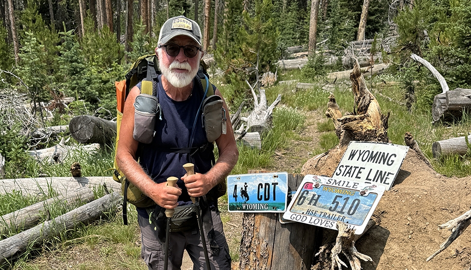
Carey Kish, aka Beerman, left, and Chukar Bird at the Wyoming state line in late July. The final stretch of Colorado from Grand Lake to the Wyoming state line was – no surprise – hot, sweaty and strenuous. At the aptly named Troublesome Pass on the north side of 12,296-foot Parkview Mountain, I met a fellow hiker named “Chukar Bird.
” We commiserated over the state’s terrain, which he artfully described as “beautiful but brutal.” Exactly. Chukar Bird and I soon joined forces and have been hiking together ever since.
We share a similar pace, mindset, warped sense of humor and enjoyment of beer. After four months and some 1,500 miles of hiking and camping almost entirely on my own, it’s been great to have some fun company over the long hours and miles. After crossing into the Cowboy State of Wyoming on a sweltering late July afternoon, it was only about 50 miles to Sage Creek Road/Wyoming Route 71 and the start of the Great Divide Basin.
In late May and early June, I was up this way to hike all 180 miles of the Basin while giving some extra time for the snowpack to melt in the San Juan Mountains of southern Colorado. I could now jump over the Basin and begin hiking into the Wind River Range at South Pass. But first I took three full days off in hiker-friendly Rawlins to rest, regroup and ready myself for the next stages of the hike.
Lazy afternoons were spent downtown at Buck’s Bar and Grill, where the food was good, the peanuts free, and pints of Pabst Blue Ribbon were, well, always a buck. Spectacular Squaretop Mountain rises high above the Green River in Wyoming’s Wind River Range. Carey Kish photo The Wind River Range had eluded me over these many years of backpacking, so I looked forward to getting a good look-see.
I was not disappointed. The rugged Cirque of the Towers is one of the most spectacular places I’ve ever visited, and Squaretop Mountain may well be the most incredible peak I’ve ever laid eyes on, excepting Maine’s Katahdin, of course. Hiking in grizzly country requires bear spray and a bear-resistant food bag.
Carey Kish photo Since South Pass, I’ve been hiking in grizzly territory, and that’ll be the case to trail’s end. I carry bear spray on my shoulder strap, and pack my food in an “Ursack,” a special tear-and-puncture-resistant bag. Each evening after dinner, I dutifully close it with a triple overhand knot and secure it to a tree using two slip knots and a climber’s carabiner.
According to the bathroom scale borrowed from the shelf in aisle number six of the Rawlins Walmart, I’ve lost 29 pounds to date. But I’m eating a lot and feeling strong and optimistic. Montana is just a few days north, while some 650 miles remain to the Canadian border.
I’m on it. Carey Kish of Mount Desert Island is thru-hiking the 2,800-mile Continental Divide Trail through the Rocky Mountains from Mexico to Canada. Follow more of his journey on Facebook and Instagram.
Comments are welcome at [email protected]. We invite you to add your comments, and we encourage a thoughtful, open and lively exchange of ideas and information on this website.
By joining the conversation, you are agreeing to our commenting policy and terms of use . You can also read our FAQs . You can modify your screen name here .
Readers may now see a Top Comments tab, which is an experimental software feature to detect and highlight comments that demonstrate compassion, reasoning, personal stories and curiosity, and encourage and promote civil discourse. Please sign into your Press Herald account to participate in conversations below. If you do not have an account, you can register or subscribe .
Questions? Please see our FAQs . Your commenting screen name has been updated. Send questions/comments to the editors.
.