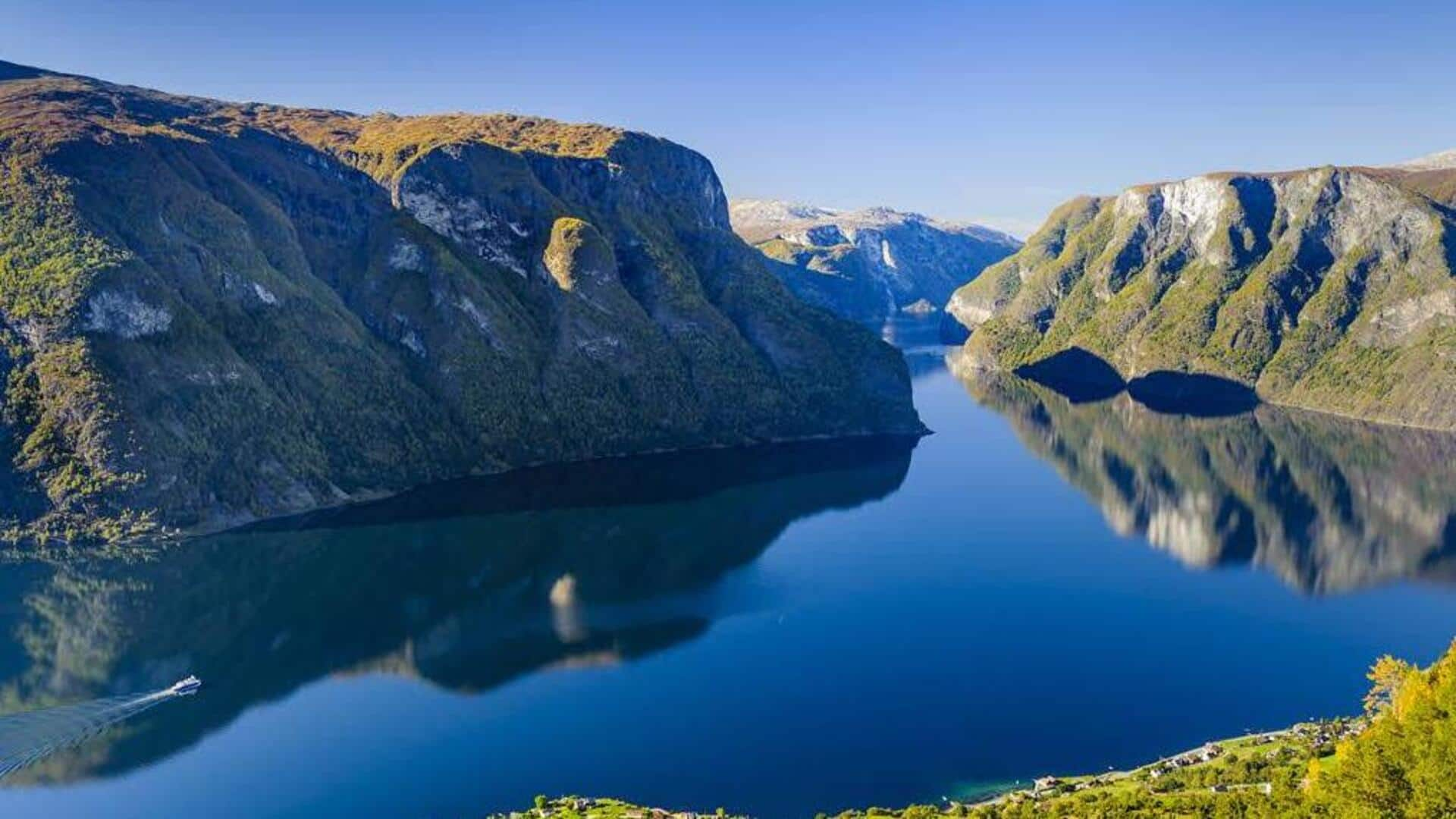
Tuesday, August 27, 2024 El Hierro, the wildest Canary Island, stands apart by embracing sustainability and preserving its natural beauty amidst the region’s mass tourism challenges. As protests against mass tourism continue to stir neighboring islands, El Hierro, the wildest and most westerly of the Canary Islands, has quietly chosen a different path. I had been hiking for only two hours, yet I had already traversed an enchanting forest of ancient laurels, their trunks wrapped in velvety moss and branches dripping with lichen.
The trails led me through lush ferns and up the black ash slopes of a volcanic caldera. Before me now was yet another breathtaking scene: the vast amphitheater of El Golfo, where brooding cliffs towered over a fertile plain and a rugged coastline pounded by turquoise waves. It was one of the most untamed and beautiful places I had ever encountered.

I was in El Hierro, a heart-shaped island off the west coast of Africa. It is the youngest, most westerly, and second smallest of the Canary Islands, formed around 1.2 million years ago from violent undersea volcanic eruptions.
This created a wild landscape of fertile valleys that give way to evergreen forests, towering cliffs, volcanic cones, and otherworldly badlands. What sets this tiny isle apart is its unique approach during a year when protests against mass tourism have erupted on neighboring islands and across Spain. El Hierro has chosen a different path.
With a population of just around 11,000 and a dramatic topography unsuited to sprawling resorts or skyscrapers, El Hierro has avoided the pitfalls of mass tourism. The lack of direct flights from outside the archipelago means the island receives only a fraction of the visitors compared to its neighbors – about 20,300 visitors in 2023, while Tenerife, the largest Canary Island, welcomed over 6.57 million.
During my visit, I zigzagged along vertigo-inducing volcanic stone paths, trekked through forests of towering Canary pines, fields of vibrant red poppies, and past pineapple plots. I crunched over black lava scattered with vivid green succulents and swam in a luminous blue natural rock pool, all with scarcely another person in sight. El Hierro has always aimed to grow visitor numbers gradually.
The island has been committed to a comprehensive sustainable development plan since 1997, which includes creating museums and visitor centers that promote its culture and traditions, focusing on activities with minimal environmental impact, and improving infrastructure while preserving nature. The island’s first paved road wasn’t built until 1962, and it still famously has only one traffic light. The landscape here changes as quickly as the weather.
You can travel from the sun-baked southern coast through barren volcanic badlands and sun-dappled forests to its tiny, mist-shrouded mountain capital, Valverde, in under an hour. With numerous microclimates and over 100 endemic species of flora and fauna, including the critically endangered El Hierro giant lizard, UNESCO designated the entire island and much of its surrounding waters as a Biosphere Reserve in 2000 and a Geopark in 2014. The island has several striking beaches – the black-pebble Timijiraque on the east coast, the red-hued Playa del Verodal on the west, and the white-sand Arenas Blancas at the western tip of El Golfo – but El Hierro is better suited for those seeking active adventures rather than a simple beach escape.
I took a white-knuckle drive up a series of hair-raising hairpin bends to reach La Dehesa, a windswept high pasture with hardy shrubs, sculptural volcanic stone, and El Sabinar, the most famous of a group of ancient juniper trees in the area. A symbol of the island’s resilience, their branches sweep the ground, and the twisted trunks bear the scars of centuries of relentless trade winds. Self-sufficiency and sustainability are woven into the fabric of life on this remote isle, rooted in the DNA of its inhabitants since the Bimbaches, the first settlers from North Africa, arrived around 120 CE.
They survived by farming, fishing, foraging, and discovering an ingenious method to collect fresh water – a challenge on an island without rivers or natural lakes. The legend of the Árbol Garoé, a sacred tree that provided the Bimbaches with all the water they needed, remains a central part of Herreño folklore. I learned just how precious every drop of water is along the Ruta del Agua (Water Route), a 16km circular trail that begins in El Hierro’s highest village, San Andrés.
The island’s history is marked by devastating droughts that led to mass emigration, most recently in the mid-20th Century. This trail highlights everything water-related, from ancient wooden water tanks to dams and divine intervention. The Virgen de los Reyes, the island’s patron saint, is credited with ending the drought of 1741 and is celebrated every four years during the Bajada de la Virgen, a month-long island-wide fiesta.
As I hiked through mist-shrouded pastures to the Árbol Garoé’s moss-lined mountain grotto, the ground squelched underfoot, and my clothes and hair became damp as if it were raining. At a high point on the route between Valverde and Tiñor, I gazed over Gorona del Viento, El Hierro’s pioneering wind-pumped hydropower station. Inaugurated in June 2014, it harnesses the island’s unique topography to combine wind and water power, providing a constant electricity supply and fulfilling the island’s long-held dream of relying entirely on renewable energy.
The island is achieving its goals. In August 2015, the power station generated all of the island’s electricity for four hours, and in 2023, it became the only island in the world to operate solely on wind and water power for 24 consecutive days, saving 13,708 tons of CO2 emissions and 4,509 tons of diesel. These are ambitious achievements for such a small island, but its success in sustainability has not gone unnoticed.
Gorona del Viento has become a global role model for renewable energy projects, and in September this year, El Hierro will receive the Canary Islands Tourism Award for Sustainable Tourism Destination, in recognition of its long-standing environmental policies. That evening, I made my way to Faro de Orchilla, a clifftop lighthouse surrounded by rippling red-hued lava, and looked out over the vast ocean. In the 2nd Century, Greek mathematician and astronomer Ptolemy placed El Hierro on the map by declaring that the prime meridian passed through Orchilla, the westernmost point of the island.
Before Columbus set sail in 1492, this was considered the edge of the known world. Although longitude zero shifted to Greenwich in 1884, as I watched the setting sun streak the water pink and gold, I knew that El Hierro would never lose its wild, edge-of-the-world allure..