The Bottom Line September has been quite a month of weather so far. On the one hand, practically every single day has been spectacularly sunny, delightfully dry, and wonderfully warm. On the other hand, most of the state has only seen a few hundredths of an inch of rain this month.
That puts us 1.5 to 2 inches below normal, month-to-date. Once again causing drought and wildfire danger concerns to spiral.

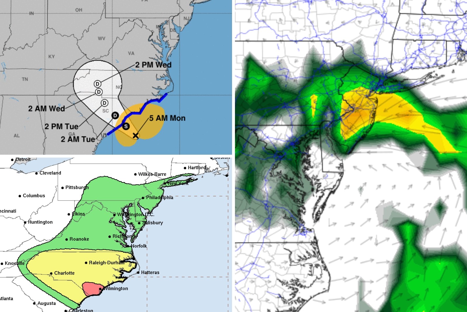
That is why this week's chance of rain is a good thing. We will take every drop we can get. An area of low pressure — which I am calling a "tropical rainstorm" for now — will make landfall along the South Carolina coast late Monday.
It will then track over the Virginias before falling apart. As pieces of energy slide through New Jersey, we will see a few rounds of rain, centered on Wednesday. And, with tropical moisture in play, pockets of heavy stuff are possible.
There is still quite a bit of uncertainty regarding a few details: Exact rainfall totals, storm exit timing, and whether it will become a full-fledged named tropical storm. Let's run through what we know and what we don't, so you can plan your last week of summer accordingly. Monday Even though we are starting to see some change to our sky and sea, Monday will be another perfectly pleasant weather day from start to finish.
Monday morning begins with temperatures in the 40s in spots, 50s for most, and 60s along the coast. Pretty much status quo so far this month — it's crisp, it's cool, it's nice. High temperatures on Monday will reach the mid to upper 70s.
That is close to normal for mid-September, and just a few degrees cooler than this weekend. We will see increasing clouds throughout the day, likely progressing from "partly sunny" to "mostly cloudy". Still breaks of sunshine and blue sky along the way.
And again, nothing will fall from those clouds. If you decide to make Monday a beach day, know there is a high risk of dangerous rip currents and rough surf along the Jersey Shore. Ocean waves up to 4 feet are expected.
Monday night stays quiet and pleasant. Expect a blanket of clouds overnight, and some patchy fog developing by Tuesday morning. Humidity will rise a bit.
All those factors will combine to keep low temperatures from dipping below the lower 60s. Tuesday There will be a shower chance on Tuesday, especially early morning and late night. But in the middle? Dry and pleasant once again.
No complaints. Skies will be mostly cloudy. High temperatures will once again reach the mid-upper 70s.
Wednesday Wednesday looks to be the wettest day of the week, although not a washout. One or two bands of rain will likely rise from south to north throughout the day Wednesday, producing scattered rain. Mainly light to moderate intensity.
Possibly heavy in pockets, especially to the south and along the coast where the forcing will be strongest and moisture will be deepest. Over an inch of rain is possible here, especially in that sweet spot to the south and east. On the flip side, the driest corner of the state will be to the north and west.
Bottom line: Carry the umbrella and plan for wet weather on Wednesday, although it is not necessarily going to pour all day. While pockets of heavy rain are possible, widespread flooding is unlikely given our dry, parched ground. Winds will stay well below tropical storm force.
And any threat of severe weather (i.e. tornadoes) should stay well to our south too.
Rough surf and minor coastal flooding are likely. With persistent clouds and raindrops, Wednesday will probably be the coolest day of the week too. Some high temperatures may struggle to even reach 70 degrees.
Thursday Thursday's forecast gets tricky, both in terms of rain chances and temperatures. I think the day will still look and feel unsettled, with a continuing chance of on-and-off rain. Best chance for showers here will be along the coast.
It will be mostly cloudy with a stiff north breeze. But high temperatures will still reach into the mid 70s — not too shabby. Friday & Beyond There is one forecast model — the Euro — that parks low pressure right along the Jersey Shore through Thursday and Friday and part of Saturday too.
Therefore keeping pockets of rain on top of us for several more days, totalling multiple inches before we finally dry out. I am leaning away from this very wet scenario — but it is worth mentioning, in case things trend in that direction. As long as that doesn't play out, our weather should be OK through the weekend.
I'm currently seeing mostly cloudy and upper 70s for Friday. Then partly sunny and lower 70s for Saturday and Sunday. A little cooler and less summer-ish.
Perfect timing, since the Autumnal Equinox and official start of Fall is coming up Sunday at 8:43 a.m. The complete list of names for the 2024 Atlantic Hurricane Season Gallery Credit: Dan Zarrow Dan Zarrow is Chief Meteorologist for Townsquare Media New Jersey.
Follow him on Facebook for the latest forecast and realtime weather updates. KEEP READING: Get answers to 51 of the most frequently asked weather questions..
..