Many of our best-known landmarks in the Pale and beyond have a fascinating tale to tell Fleet Street The Ouzel Galley stone carving Strokestown’s Broad Avenue Misery Hill Sick & Indigent Roomkeepers Society Baggorath Castle 10 Anglesea Street 10 fascinating stories from the Pale and beyond: Baggorath Castle With such a distinctive name, I knew there must be an interesting story behind “Baggot”, and I was right. I went down a rabbit hole into old city maps, and it turns out that Upper Baggot Street, near present-day Searsons Pub, was the location of Baggotrath Castle — a medieval fortress that was the toughest stronghold in Dublin and the scene of many bloody battles, notably, the Battle of Rathmines in 1649. “Baggot” comes from the surname of Sir Robert Bagod, an Irish judge and landowner in the 13th century.
This is where he built his fortress. Later, it passed to the Hiberno-Norman Fitzwilliam family. It existed for five centuries before the ruins were demolished to make way for the familiar red-brick terrace we know today.

But of course, Baggot Street is the modern name. Back then, it was called something different..
. Here’s one to tell your mates the next time you’re having a pint in Toners. Present-day Lower Baggot Street, just up the road from Baggotrath Castle, was called Gallows Road up until 1773.
It was here where Ireland saw some of its grizzliest executions. This is where brothel madame, purported serial killer and suspected witch Darkey Kelly was burnt at the stake. Archbishop of Cashel Dermot O’Hurley met his end on Gallows Road too.
Captured and tortured in the late 16th century, he was ultimately hanged by the Crown for refusing to renounce his faith. Sick & Indigent Roomkeepers Society Passing through Dublin Castle’s iconic arch onto Palace Street, you can’t miss the striking building on your left. Its facade proudly displays the inscription ‘Sick & Indigent Roomkeepers Society Founded AD 1790’.
This is the original headquarters of Dublin’s oldest operating charity, founded in the 18th century by local middle-class Dubliners to aid the city’s poor. Interestingly, the building was also once owned by the family of Robert Emmet, the Irish rebel leader. And speaking of Palace Street, this is considered Dublin’s shortest street, with just two addresses on it.
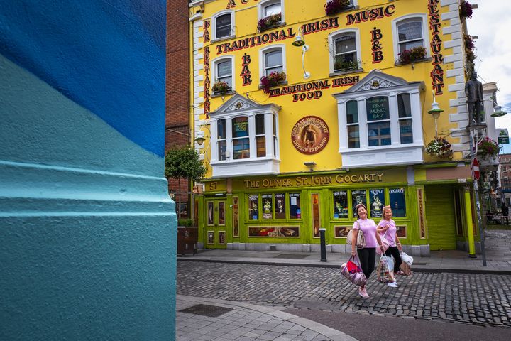
10 Anglesea Street To many, it is simply known as “that gorgeous blue building in Temple Bar”, but few know the story of the man behind it. Number 10 Anglesea Street was originally constructed around 1740, making it one of the oldest buildings in Dublin’s tourist hotspot. It was extensively remodelled in 1898 by local eccentric stockbroker and philanthropist Laurence Ambrose ‘Larkey’ Waldron.
Known for his generosity and patronage of the arts, Larkey was a well-known figure in Dublin, often seen walking behind his horse-drawn carriage and letting his dog take the front seat. Look out for his initials, LAW, on the facade. Misery Hill The blue street sign next to Bord Gáis Energy Theatre has become something of a tourist attraction in recent years.
I’ve heard lots of stories about the origin of the name. One Pearse Street native told me recently, “My Ma said the banshee lived on Misery Hill to stop me from going over there..
.” The most plausible origin story, however, dates back to the 13th century. Misery Hill, and nearby Lazer Lane, were linked to a ‘Leper hospital’, as they were known then.
The clue is in the Irish name for Lazer Lane, Lána na Lobhar. This translates to ‘Leper’s Lane’. Here is where pilgrims gathered before departing for the Camino de Santiago pilgrimage in Spain.
A make-shift hospital was established here by the Order of Saint Lazarus to treat those with leprosy before they headed off to Spain. “Lazer” is a reference to Saint Lazarus, and apparently the care the sick received was absolutely miserable, which is why it became known as Misery Hill. The Ouzel Galley stone carving While you’re wandering through Temple Bar, keep an eye out for a curious stone carving of a tall ship right next to Krispy Kreme, tucked away in Central Bank Plaza.
This is all that remains of the once-influential Ouzel Galley Society, a bizarre chapter in Irish maritime history that is still shrouded in mystery and conspiracy theories. The stone carving depicts the infamous Ouzel Galley, an Irish merchant ship that vanished without a trace in 1695, baffling the public and creating a complex legal and financial headache. To settle insurance claims and other matters, a group of prominent Dublin merchants, including the legendary John Jameson and Arthur Guinness, came together.
Years later, the insurance was paid out, the crew were mourned, and life moved on. But then, in 1700, the impossible happened: the Ouzel Galley reappeared, fully crewed and loaded with treasure. The ship’s Captain Massey claimed Algerian pirates had captured the vessel and used it for piracy, but many suspect the Irish crew were the real culprits.
The truth remains a mystery, which is why the Ouzel Galley is so legendary. This extraordinary incident led to the formation of the Ouzel Galley Society in 1705, a permanent body dedicated to resolving maritime disputes. While the society is long gone, the building remains, and the stone carving serves as a reminder of this maritime mystery.
Fleet Street It’s hard to imagine now, with its bustling pubs and rock ’n’ roll themed cafes, but Fleet Street was once underwater. Before becoming one of Dublin’s busiest tourist spots, this land was part of the Liffey. It wasn’t until the mid-1600s that the land was reclaimed.
Interestingly, the street’s name may not be a nod to London’s Fleet Street, but rather a reflection of its past: a place where fleets of ships once docked. One of my favourite pieces of hidden history is Isolde’s Tower, a 13th-century Anglo-Norman defence tower, which is quite literally hidden under an apartment block. This ruin was discovered in 1993 during construction in the area.
Several skulls were found here, perhaps evidence that heads were placed on spikes to deter invaders coming in from the Liffey. Isolde’s Tower served as one of the corners of the city walls, some of which are still standing in the Liberties. Strokestown’s Broad Avenue No list about streets would be complete without going beyond the Pale and giving a nod to Strokestown in Co Roscommon.
It is home to Ireland’s second-widest street, a grand avenue that once held the European title (only to be robbed by Dublin’s O’Connell Street in the late 18th century). This unusually, and quite ridiculously, wide road is the main thoroughfare of the town, designed by the wealthy Anglo-Irish Mahon family, former landlords of Strokestown House. The family were awarded the land for their loyalty to Cromwell three centuries prior and were in charge of the town planning.
They undertook several questionable development projects like this, partly to give locals work and partly because...
well, they had notions. While the street reflects their wealth and power, the estate’s archives, discovered in the 1980s, reveal the harsh realities of life for normal folk in Strokestown during Ireland’s darkest times. During the Great Famine, conflict and unrest led to the assassination of landlord Major Denis Mahon.
Today, the original Palladian mansion survives, with its interior meticulously preserved. It’s also home to the National Famine Museum, and it continues to be cared for by the Irish Heritage Trust. It’s a phenomenal place to visit.
Join the Irish Independent WhatsApp channel Stay up to date with all the latest news.